Waterloo Hydrogeologic Visual MODFLOW Flex 10.0 (Win):
Visual MODFLOW Flex stands as the premier software solution for groundwater flow and contaminant transport modeling, seamlessly integrating industry-standard codes, advanced analysis tools, and captivating 3D visualization capabilities within a single environment.
Applications of Visual MODFLOW Flex:
Why Choose Visual MODFLOW Flex?
Efficient Model Building: Adapt model inputs and grid designs flexibly as project objectives evolve or more data become available. The software's intuitive, workflow-driven graphical user interface streamlines modeling steps, presenting current, completed, and pending tasks for easy navigation.
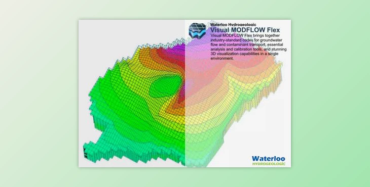
Credible and Complex Modeling: Equipped to handle vast datasets and high-resolution information, Visual MODFLOW Flex can simulate large-scale groundwater systems effectively. Visualize model inputs and outputs alongside raw GIS field data in 3D, bolstering model credibility by demonstrating data transformation from conceptual to numerical stages.
Powerful Data Visualization: Leveraging state-of-the-art 3D visualization technology, Visual MODFLOW Flex empowers users to present data effectively through stunning visual renderings of hydrogeologic models. Generate cut-away and cross-sectional views, create 3D animations, and overlay raster images for comprehensive data representation.
Efficient Management of Multiple Models: Manage multiple model scenarios within a single project, facilitating direct comparisons and analyses to assess uncertainty and improve model credibility. Generate parallel models to evaluate alternative interpretations and hypotheses effectively.
Full GIS Integration: Seamlessly construct grid-independent hydrogeologic conceptual models using existing GIS datasets. Benefit from quick data importing, automatic coordinate system conversion, and intuitive boundary definition from imported GIS data.
Integrated 3D Conceptual and Numerical Modeling: Visual MODFLOW Flex offers a seamless transition from raw data to numerical model within a unified modeling environment. Define complex geology, interpret GIS data, and analyze model results with raw data across various views effortlessly.
Flexible Grid Options: Choose from a range of grid types to generate numerical models, including structured and unstructured grids tailored to diverse applications and geological conditions. Experiment with different grid types to optimize simulation accuracy and stability.
